
Mckenzie Bridge Guidebook
Food scene
Across the bridge from the Log Cabin is the Mckenzie Bridge local hangout! Here you can find an huge outdoor courtyard that serves a full menu, beer to tap, and live music every Thursday – Sunday from 5:30pm to 8:30pm. Hours has been changing due to covid so please call ahead to confirm that they are open.
24 persone del luogo consigliano
McKenzie General Store & Obsidian Grill Restaurant
91837 Taylor Rd Across the bridge from the Log Cabin is the Mckenzie Bridge local hangout! Here you can find an huge outdoor courtyard that serves a full menu, beer to tap, and live music every Thursday – Sunday from 5:30pm to 8:30pm. Hours has been changing due to covid so please call ahead to confirm that they are open.
At Takodas we are a full service restaurant centrally located in Rainbow, Oregon in the beautiful McKenzie River Valley. The McKenzie River is our backyard. Our goal is to provide delicious, homemade food with warm & friendly service.
We are moments away from Tokatee Golf Course, whitewater rafting, fishing, hiking, camping and snow sports.
Address
91806 Mill Creek Rd Blue River, OR
Phone
(541) 822-1153
E-mail
takodas@gmail.com
Website
www.takodasrainbow.com
26 persone del luogo consigliano
Takoda's Restaurant
91806 Mill Creek RdAt Takodas we are a full service restaurant centrally located in Rainbow, Oregon in the beautiful McKenzie River Valley. The McKenzie River is our backyard. Our goal is to provide delicious, homemade food with warm & friendly service.
We are moments away from Tokatee Golf Course, whitewater rafting, fishing, hiking, camping and snow sports.
Address
91806 Mill Creek Rd Blue River, OR
Phone
(541) 822-1153
E-mail
takodas@gmail.com
Website
www.takodasrainbow.com
Local grocery store that has any staples you might need
9 persone del luogo consigliano
Blue Sky Market with Shell
91808 Mill Creek RdLocal grocery store that has any staples you might need
Sightseeing
Hour and a half hike along the Mckenzie River Trial to a beautiful turquoise swimming hole.
57 persone del luogo consigliano
Cascate Tamolitch (Piscina Blu)
Hour and a half hike along the Mckenzie River Trial to a beautiful turquoise swimming hole.
The MRT is a beautiful trail with a mix of beginner, intermediate, and advanced sections. It is often ridden downhill as a shuttle, but if you are fit you can ride part or all of it uphill.
Above the "blue pool" (Tamolithch Falls) is mostly intermediate with a few technical bits. There are three main areas of technical in the upper third section of the MRT: east side of Clear Lake, a short section below Sahalie Falls, and mostly after Tamolitch Falls where it becomes very rugged and rocky - great fun if you like technical challenges, wise to walk if not.
From the start, you'll ride a few miles of moderate singeltrack. At Clear Lake you can continue the easy-moderate trail on the westside, or opt for the highly technical section on the east side (a sunny, sweltering hot, sharp lava rock, tube eating option if you like that kind of adventure...credit to Mark for that). After the lake, it's back to nice flow.
A bit of technical sections below Sahalie Falls, quite a bit more below Tamolitch Falls. If you don't care to ride the volcanic rock, you need to walk it, there are no ride-arounds.
After you encounter Trail Bridge Campground, the riding is fairly smooth again, with a very smooth finish, but watch out for a very steep embankment and narrow trail shortly after you cross the log bridge over the Smith River feeding into the reservoir. If you've got wide handlebars it is easy to bump roots/rocks sticking out up hill and careen down the cliff.
27 persone del luogo consigliano
McKenzie River Trail
56621 McKenzie HwyThe MRT is a beautiful trail with a mix of beginner, intermediate, and advanced sections. It is often ridden downhill as a shuttle, but if you are fit you can ride part or all of it uphill.
Above the "blue pool" (Tamolithch Falls) is mostly intermediate with a few technical bits. There are three main areas of technical in the upper third section of the MRT: east side of Clear Lake, a short section below Sahalie Falls, and mostly after Tamolitch Falls where it becomes very rugged and rocky - great fun if you like technical challenges, wise to walk if not.
From the start, you'll ride a few miles of moderate singeltrack. At Clear Lake you can continue the easy-moderate trail on the westside, or opt for the highly technical section on the east side (a sunny, sweltering hot, sharp lava rock, tube eating option if you like that kind of adventure...credit to Mark for that). After the lake, it's back to nice flow.
A bit of technical sections below Sahalie Falls, quite a bit more below Tamolitch Falls. If you don't care to ride the volcanic rock, you need to walk it, there are no ride-arounds.
After you encounter Trail Bridge Campground, the riding is fairly smooth again, with a very smooth finish, but watch out for a very steep embankment and narrow trail shortly after you cross the log bridge over the Smith River feeding into the reservoir. If you've got wide handlebars it is easy to bump roots/rocks sticking out up hill and careen down the cliff.
This 1.6 miles loop trail travels through open lava fields and dense forest, offering views of two waterfalls.
6,000 years ago glaciers cut this canyon out, now these two falls run over the glacier cut cliff. Lava from cinder cones near North Sister then filled the valley floor. As the water falls over the cliff and down into the porous lava it sinks back underground so it appears as if the water just disappears, without an outlet.
14 persone del luogo consigliano
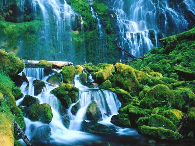
Proxy Falls
This 1.6 miles loop trail travels through open lava fields and dense forest, offering views of two waterfalls.
6,000 years ago glaciers cut this canyon out, now these two falls run over the glacier cut cliff. Lava from cinder cones near North Sister then filled the valley floor. As the water falls over the cliff and down into the porous lava it sinks back underground so it appears as if the water just disappears, without an outlet.
Clear Lake has a long history of being a popular recreation spot in the high Cascades. It was discovered in 1859 by a party of men who were searching for a route over the Cascade Mountains. They had followed an Indian trail down Hackleman Creek and after considerable scouting found Fish Lake and then Clear Lake.
Clear Lake is about 142 acres in size and lies at an elevation of 3,012 feet, with a maximum depth of 175 feet. It is one of the clearest and coldest lakes in the Cascades. It lies just off Highway 126 about 21 miles east of McKenzie Bridge. Clear Lake is excellent for canoeing and other non-motorized boats. Fishing is good at Clear Lake. Brook trout and cutthroat trout reproduce naturally in the lake. Rainbow trout are stocked annually.
Cold Water Cove Campground has 34 campsites and each site is equipped with a picnic table and campfire ring. Adjacent to the campground is the Clear Lake Resort at which cabins are rented and there is a grocery and tackle shop with a restaurant that sells meals during the recreation season, from about late May through the fall.
How did geological processes shape what you see at Clear Lake? Why is the water so clear and blue? What other diverse features exist because of a volcanic eruption 3,000 years ago? Take a walk along the Clear Lake Loop Trail to discover the answers as you walk through groves of ancient firs and across stark fields of lava to the source of the McKenzie River.
28 persone del luogo consigliano
Clear Lake
Clear Lake has a long history of being a popular recreation spot in the high Cascades. It was discovered in 1859 by a party of men who were searching for a route over the Cascade Mountains. They had followed an Indian trail down Hackleman Creek and after considerable scouting found Fish Lake and then Clear Lake.
Clear Lake is about 142 acres in size and lies at an elevation of 3,012 feet, with a maximum depth of 175 feet. It is one of the clearest and coldest lakes in the Cascades. It lies just off Highway 126 about 21 miles east of McKenzie Bridge. Clear Lake is excellent for canoeing and other non-motorized boats. Fishing is good at Clear Lake. Brook trout and cutthroat trout reproduce naturally in the lake. Rainbow trout are stocked annually.
Cold Water Cove Campground has 34 campsites and each site is equipped with a picnic table and campfire ring. Adjacent to the campground is the Clear Lake Resort at which cabins are rented and there is a grocery and tackle shop with a restaurant that sells meals during the recreation season, from about late May through the fall.
How did geological processes shape what you see at Clear Lake? Why is the water so clear and blue? What other diverse features exist because of a volcanic eruption 3,000 years ago? Take a walk along the Clear Lake Loop Trail to discover the answers as you walk through groves of ancient firs and across stark fields of lava to the source of the McKenzie River.