
Katie’s Bothy Guidebook
Sightseeing
If walking the C2C this is one of the highlights of the walk, as you reach Kidsty Pike the highest point on the walk you will see Haweswater 2000ft below you. You will walk along its western shore before heading over the fields to Shap. If staying at the bothy you can walk to Haweswater Reservoir over the fells or following the old construction road from the bothy - its about a 13 mile round trip so take a picnic. Follow the Swindale valley for a wild swim in the river to cool off and revive your feet.
21 persone del luogo consigliano
Haweswater Reservoir
If walking the C2C this is one of the highlights of the walk, as you reach Kidsty Pike the highest point on the walk you will see Haweswater 2000ft below you. You will walk along its western shore before heading over the fields to Shap. If staying at the bothy you can walk to Haweswater Reservoir over the fells or following the old construction road from the bothy - its about a 13 mile round trip so take a picnic. Follow the Swindale valley for a wild swim in the river to cool off and revive your feet.
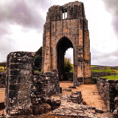
If walking the C2C you will pass the Abbey as you near Shap or its a 4 mile round trip walk from the bothy following the river Lowther avoiding all roads and along the Edge of the National Park. Founded in the late 12th century the Abbey is in the secluded and beautiful valley of the river Lowther, Shap Abbey was one of 32 religious houses in Britain belonging to the Premonstratensian order of canons. Today the impressive 15th century tower and other remains can be explored with the help of information panels that guide you around the abbey and illustrate daily monastic life.
9 persone del luogo consigliano
Shap Abbey
Keld LaneIf walking the C2C you will pass the Abbey as you near Shap or its a 4 mile round trip walk from the bothy following the river Lowther avoiding all roads and along the Edge of the National Park. Founded in the late 12th century the Abbey is in the secluded and beautiful valley of the river Lowther, Shap Abbey was one of 32 religious houses in Britain belonging to the Premonstratensian order of canons. Today the impressive 15th century tower and other remains can be explored with the help of information panels that guide you around the abbey and illustrate daily monastic life.
An easy circular walk round the reservoir starting from the bothy following the river Lowther and the edge of the National Park. plenty of places to picnic and play in the river - take some fishing nets for the kids.
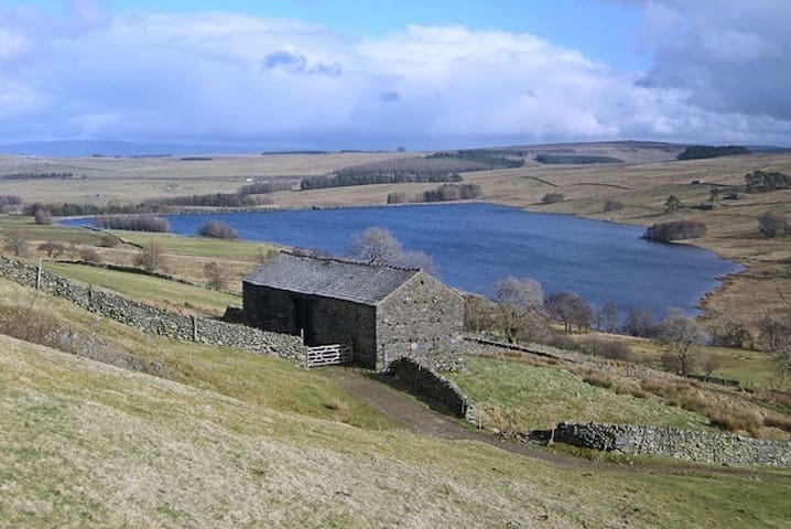
Wet Sleddale Reservoir
An easy circular walk round the reservoir starting from the bothy following the river Lowther and the edge of the National Park. plenty of places to picnic and play in the river - take some fishing nets for the kids.
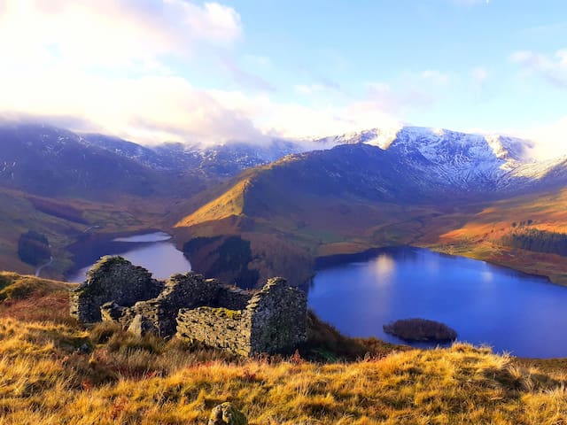
Walking the C2C you will pass over these mountains at Kidsty Pike and High Street will be to the south but you will head down to haweswater and Shap. The bothy is a short drive or 13 mile round trip walk to some of the highest mountains in the Lake Disrtict. The view iwith the ruined building is overlooking the mountains walking from the Swindale valley - one of the best veiws in the Lake District. Walking back through swindale you can take a wild swim in the river to cool off.

High Street Mountain
Walking the C2C you will pass over these mountains at Kidsty Pike and High Street will be to the south but you will head down to haweswater and Shap. The bothy is a short drive or 13 mile round trip walk to some of the highest mountains in the Lake Disrtict. The view iwith the ruined building is overlooking the mountains walking from the Swindale valley - one of the best veiws in the Lake District. Walking back through swindale you can take a wild swim in the river to cool off.
10 mile round trip walk to one of the most fantastic castles in the UK complete with cafe for a half way coffee and cake.
97 persone del luogo consigliano
Castello e giardini di Lowther
10 mile round trip walk to one of the most fantastic castles in the UK complete with cafe for a half way coffee and cake.
A 4 mile round trip walk from the bothy either following the river, the road or footpaths from the bothy. The medieval Chapel, is owned by the National Trust, and is one of their more remote religious sites.
It is probable that Keld was a village in Roman times. What is now known generally as the ‘Chapel at Keld’ is believed initially to have been a ‘chantry’ and a part of Shap Abbey. This was a Premonstratensian foundation, which originated at Preston Patrick in about 1122, during the reign of Henry II. It appears to have moved to Shap in about 1125.
The chapel appears to date back to the 15th century. About 1650 it was occupied as a dwelling house.
National Trust - Keld Chapel
Keld LaneA 4 mile round trip walk from the bothy either following the river, the road or footpaths from the bothy. The medieval Chapel, is owned by the National Trust, and is one of their more remote religious sites.
It is probable that Keld was a village in Roman times. What is now known generally as the ‘Chapel at Keld’ is believed initially to have been a ‘chantry’ and a part of Shap Abbey. This was a Premonstratensian foundation, which originated at Preston Patrick in about 1122, during the reign of Henry II. It appears to have moved to Shap in about 1125.
The chapel appears to date back to the 15th century. About 1650 it was occupied as a dwelling house.
4 miles away following footpaths over the fells is Swindale valley which is one of the most remote parts of the National Park.
Swindale Beck
4 miles away following footpaths over the fells is Swindale valley which is one of the most remote parts of the National Park.
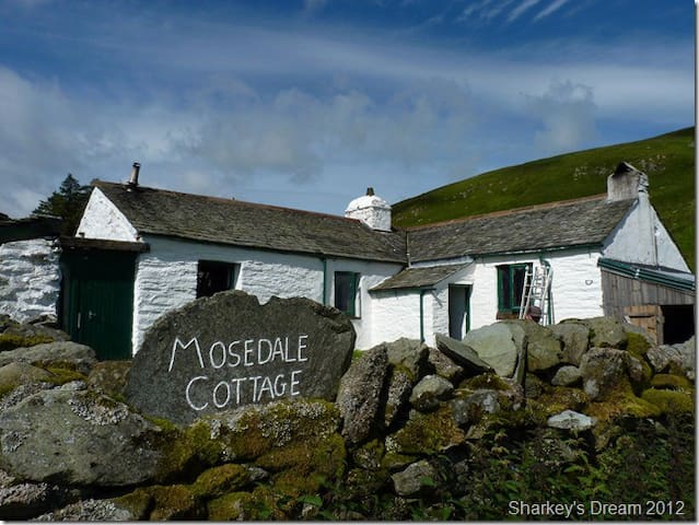
This is the real deal in bothying and its a five mile walk over open fells with bogs so a committing walk especially if wet. However this is one of only 3 bothies in the lake District and you will be completely remote from the world - wooden plaforms to sleep on, a wood burning stove and water from the river BUT you will never forget it. Stay with us for a night and then head off the next morning for a night there and then aonther night with us before you head off home. You will need to take everything with you including firewood or coal !!!!
Mosedale Cottage Bothy
This is the real deal in bothying and its a five mile walk over open fells with bogs so a committing walk especially if wet. However this is one of only 3 bothies in the lake District and you will be completely remote from the world - wooden plaforms to sleep on, a wood burning stove and water from the river BUT you will never forget it. Stay with us for a night and then head off the next morning for a night there and then aonther night with us before you head off home. You will need to take everything with you including firewood or coal !!!!
In the middle of the village on the sports field - open between May and September and on the way to the bothy from the West so why not have a swim to cool off after the long walk from patterdale. Showers and a small shop but check the opening times on their website.
Shap Swimming Pool
Gayle AvenueIn the middle of the village on the sports field - open between May and September and on the way to the bothy from the West so why not have a swim to cool off after the long walk from patterdale. Showers and a small shop but check the opening times on their website.
Sleddale Hall is a 3 mile walk from the bothy and stood in as "Crow Crag", the Lake District cottage owned by Uncle Monty in the film Withnail and I. The scenes at Sleddale Hall were filmed in August 1986. Actor Richard E. Grant, who played Withnail, recorded his first impressions of the farmhouse in his published diary:
2nd August. Mini-bus together out to the location in Wet Sleddale, supposedly the wettest corner of the United Kingdom, through numerous gates, up a mountainside to an abandoned cottage on the water board estate. Perfect. Looks exactly like the script suggests.
Filming took place both in the downstairs rooms of the house and in the exterior areas, including the small courtyard. The red phone box in the movie is also near the bothy at Bampton Grange.
Sleddale Hall
Sleddale Hall is a 3 mile walk from the bothy and stood in as "Crow Crag", the Lake District cottage owned by Uncle Monty in the film Withnail and I. The scenes at Sleddale Hall were filmed in August 1986. Actor Richard E. Grant, who played Withnail, recorded his first impressions of the farmhouse in his published diary:
2nd August. Mini-bus together out to the location in Wet Sleddale, supposedly the wettest corner of the United Kingdom, through numerous gates, up a mountainside to an abandoned cottage on the water board estate. Perfect. Looks exactly like the script suggests.
Filming took place both in the downstairs rooms of the house and in the exterior areas, including the small courtyard. The red phone box in the movie is also near the bothy at Bampton Grange.
Food scene
One of the best fish and chip shops in the UK and now they serve Pizzas as well. They have an ordering App and you can get deliveries to the bothy !
19 persone del luogo consigliano
Shap Chippy
One of the best fish and chip shops in the UK and now they serve Pizzas as well. They have an ordering App and you can get deliveries to the bothy !
Built in the 30s when the reservour was filled and the hamlet of Mardale flooded. A full days walk to the hotel for lunch and back either over the fells or along the old cement road either way its a great walk.
Haweswater Hotel
Lakeside RoadBuilt in the 30s when the reservour was filled and the hamlet of Mardale flooded. A full days walk to the hotel for lunch and back either over the fells or along the old cement road either way its a great walk.
A 6 mile walk over the fells via Wet Sleddale or along the old Shap road to Shap Wells Hotel where you can have lunch in a Victorian Spa Hotel.
Shap Wells Hotel
B6261A 6 mile walk over the fells via Wet Sleddale or along the old Shap road to Shap Wells Hotel where you can have lunch in a Victorian Spa Hotel.
Newsagents and post office in the middle of the village opposite the sports field. Sells sweets, sandwiches, drinks, cakes and does cashback.
Shap Post Office - Andersons Village Newsagents & Post Office
Main StreetNewsagents and post office in the middle of the village opposite the sports field. Sells sweets, sandwiches, drinks, cakes and does cashback.
One of 3 pubs in the village and is opposite the turn into and leaving Shap on the C2C
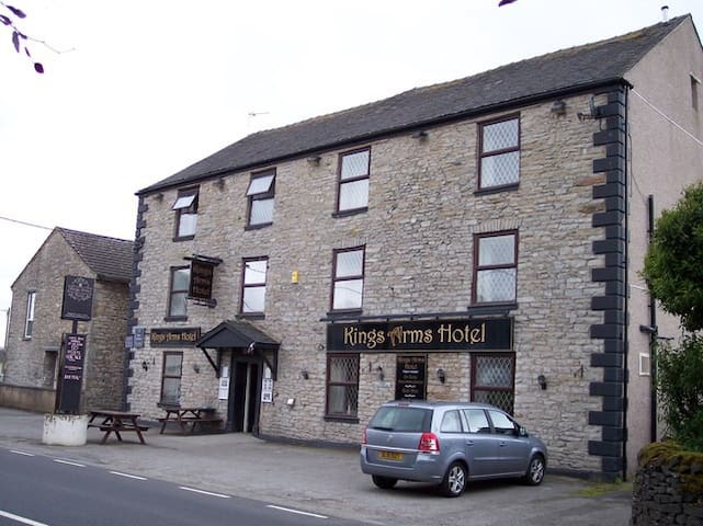
Kings Arms Hotel
Main StreetOne of 3 pubs in the village and is opposite the turn into and leaving Shap on the C2C
Your one stop shop to stock up on food and drink in the village everything you need plus hot pies and a coffee machine. Cash point outside and cashback inside when making a purchase.
14 persone del luogo consigliano
Lakes and Dales Co-operative
Main StreetYour one stop shop to stock up on food and drink in the village everything you need plus hot pies and a coffee machine. Cash point outside and cashback inside when making a purchase.
This is the closest pub to the bothy and you can see it as you leave the bothy - the C2C crosses the M6 using the bridge you can see above the pub.
The Greyhound Hotel, Bar & Restaurant
Main StreetThis is the closest pub to the bothy and you can see it as you leave the bothy - the C2C crosses the M6 using the bridge you can see above the pub.
Pizza take away and deliveries - grab one of these on your way to the bothy from the C2C westerly or order by phone or App.
19 persone del luogo consigliano
Shap Chippy
Pizza take away and deliveries - grab one of these on your way to the bothy from the C2C westerly or order by phone or App.
City/town information
The nearest town to the bothy at 10 miles away - there is a main line train station and bus service to Shap however getting from Penrith to Shap is an issue. There are two buses a week on a Tuesday and Thursday from the Station but other than that its a taxi ride. There are several supermarkets and a Go Outdorrs for camping kit.
76 persone del luogo consigliano
Penrith
The nearest town to the bothy at 10 miles away - there is a main line train station and bus service to Shap however getting from Penrith to Shap is an issue. There are two buses a week on a Tuesday and Thursday from the Station but other than that its a taxi ride. There are several supermarkets and a Go Outdorrs for camping kit.
Shops
The world famous New Balance factory shoe shop - if you need new walking shoes or socks then this is the place to get them. Situated in the middle of the village near the zebra crossing.
New Balance Athletic Shoes
1 & 2 Market SquareThe world famous New Balance factory shoe shop - if you need new walking shoes or socks then this is the place to get them. Situated in the middle of the village near the zebra crossing.
Neighbourhoods
Shap is a very ancient place, the oldest proof of people living there are the stone circles and avenues that once formed Shap Stones. These were quite as important as places like Avebury and Stonehenge. There is not much left from the circles and avenue today except a few boulders next to the railway embankment east of the A6 beyond Fell Garage – this is what is left of one circle. There are some big stones in the fields between Shap and Keld, and some of them have special names such as the Googleby Stone.
When you turn off the main road to walk down the small lane to the bothy you will walk through what was once the center of the main stone circle and if you look in the walls you will see parts of the stones that made up the circle.
Shap has not always been called that name, the first written records call it Heppe, and this is believed to come from the word ‘heap’ referring to a pile of stones and quite likely to the Shap Stones.
Shap Abbey was begun in 1199, and was very important; it closed in 1540 when all the monasteries and abbeys were closed.
In 1984 when they were laying the gas pipeline near the Shap Granite Pink Quarry they found a 13th century canoe preserved in the peaty ground.
There were two parts to the place, Shap or Heppe round the church and market place, and another little village near the Greyhound Hotel called Brackenber.
The village grew up because of the road that ran through it, this would first have been a track, and people would have walked or ridden horses, then later they would have used wagons then the stagecoaches that took quite a lot of people at the same time, about six or eight people inside in the more expensive seats and people who could not afford that would have had to sit up on the top in all the wind rain and snow. Some of the big hotels like the Greyhound and Kings Arms kept horses so that the stagecoaches could change their tired horses for different ones – a bit like filling your car with fuel at a garage.
In 1844 the railway was begun and opened in 1846; Shap had a station near the Greyhound.
In 1865 Shap Granite Works opened, it had two quarries and a concrete works and was the main place that Shap people worked; the company built a lot of new houses for their workers and filled the gaps between Shap and Brackenber to make one big village. The limestone quarry at Shap Beck opening in the 1930s and Hardendale quarry in 1963.
A workhouse for poor people who had nowhere to live was built in 1877, it then became a children’s home for children with no families, and now it is houses called Brackenber Lodge. This is where the bothy is situated, back in 1877 the building where you will stay was the wash house for the workhouse.
The road was always very busy because it was the main road from England into Scotland and all the traffic came through the village. Because it was a busy place there were quite a lot of shops.
There were two schools one for boys and one for girls, these were made into one school in 1955 using the boys school building, and the girls school became a secondary school then magistrates court, youth centre and is now the library.
Some new council houses (Croft Avenue and Gayle Avenue) were built in 1951 and 1953 and more (West Lane) in 1963. Parkers Croft, Lynchetts and Peggy Nut were built in the 1990s, so Shap is now about four times the size it was in 1950.
The Wet Sleddale dam was built in the 1960s and the M6 Motorway opened in 1970, so Shap became a lot quieter with much less traffic.
7 persone del luogo consigliano
Shap
Shap is a very ancient place, the oldest proof of people living there are the stone circles and avenues that once formed Shap Stones. These were quite as important as places like Avebury and Stonehenge. There is not much left from the circles and avenue today except a few boulders next to the railway embankment east of the A6 beyond Fell Garage – this is what is left of one circle. There are some big stones in the fields between Shap and Keld, and some of them have special names such as the Googleby Stone.
When you turn off the main road to walk down the small lane to the bothy you will walk through what was once the center of the main stone circle and if you look in the walls you will see parts of the stones that made up the circle.
Shap has not always been called that name, the first written records call it Heppe, and this is believed to come from the word ‘heap’ referring to a pile of stones and quite likely to the Shap Stones.
Shap Abbey was begun in 1199, and was very important; it closed in 1540 when all the monasteries and abbeys were closed.
In 1984 when they were laying the gas pipeline near the Shap Granite Pink Quarry they found a 13th century canoe preserved in the peaty ground.
There were two parts to the place, Shap or Heppe round the church and market place, and another little village near the Greyhound Hotel called Brackenber.
The village grew up because of the road that ran through it, this would first have been a track, and people would have walked or ridden horses, then later they would have used wagons then the stagecoaches that took quite a lot of people at the same time, about six or eight people inside in the more expensive seats and people who could not afford that would have had to sit up on the top in all the wind rain and snow. Some of the big hotels like the Greyhound and Kings Arms kept horses so that the stagecoaches could change their tired horses for different ones – a bit like filling your car with fuel at a garage.
In 1844 the railway was begun and opened in 1846; Shap had a station near the Greyhound.
In 1865 Shap Granite Works opened, it had two quarries and a concrete works and was the main place that Shap people worked; the company built a lot of new houses for their workers and filled the gaps between Shap and Brackenber to make one big village. The limestone quarry at Shap Beck opening in the 1930s and Hardendale quarry in 1963.
A workhouse for poor people who had nowhere to live was built in 1877, it then became a children’s home for children with no families, and now it is houses called Brackenber Lodge. This is where the bothy is situated, back in 1877 the building where you will stay was the wash house for the workhouse.
The road was always very busy because it was the main road from England into Scotland and all the traffic came through the village. Because it was a busy place there were quite a lot of shops.
There were two schools one for boys and one for girls, these were made into one school in 1955 using the boys school building, and the girls school became a secondary school then magistrates court, youth centre and is now the library.
Some new council houses (Croft Avenue and Gayle Avenue) were built in 1951 and 1953 and more (West Lane) in 1963. Parkers Croft, Lynchetts and Peggy Nut were built in the 1990s, so Shap is now about four times the size it was in 1950.
The Wet Sleddale dam was built in the 1960s and the M6 Motorway opened in 1970, so Shap became a lot quieter with much less traffic.
Consigli per viaggiatori
Cosa portare
Think camping without a tent and thats Bothying
The sleeping platforms (old doors) have a foam matress on them but an inflatable matress and pillow will be much more comfortable.