
Ταξιδιωτικός οδηγός του/της Georgia
Site seeing
Must visit: (8 km from Sea and Sun) a walk in the historic center of the city, a tour through the crossroads and the cobbled roads of civilizations, beginning from the central point of Chania, the Municipal Market , which opened in 1913 on the demolished Venetian bastion Piatta Forma.
399 persone del luogo consigliano
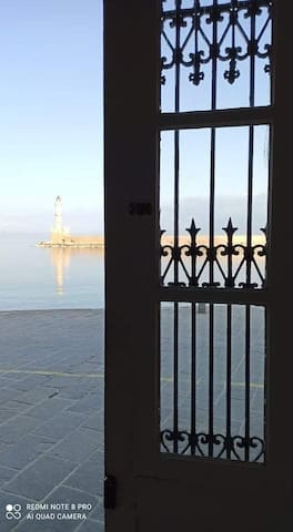
Vecchio Porto Veneziano
8 Agiou MarkouMust visit: (8 km from Sea and Sun) a walk in the historic center of the city, a tour through the crossroads and the cobbled roads of civilizations, beginning from the central point of Chania, the Municipal Market , which opened in 1913 on the demolished Venetian bastion Piatta Forma.
(2km from Sea and Sun) A living museum of historical memory that is worth seeing by any visitor of Crete that records the suffering of the Greek people during the German Occupation, is the galleries of Platanias. The shelter was built below the church of Agios Dimitrios at Pano Platanias by the requisitioned locals, for the Germans, and is open in order to serve as a memorial museum for the Second World War.
Locals say that when the Germans occupied the island, due to the strategic position of Platanias village, they settled infantry and artillery. They got the best houses for the officers, built barracks and camps for soldiers in various places, but for storing ammunition and other supplies they built underground tunnels in various positions.
The most important of these tunnels is the one below the church of Agios Dimitrios. Despite the abandonment of so many decades, it is in good position. This place was preferred because of the presence of the church that protected the tunnels from attacks and due to the soft limestone that was ideal for fast digging by the requisitioned workers. The galleries have a length of 120 meters while inside the shelter there are 10 “blind” chambers and two exits which are connected externally with trenches.
The place hosts several interesting objects from the period of the German occupation and important photographs from the Battle of Crete.
Πηγή: ⭐ Travel Guide for Island Crete ⛵, Greece❗ - German Tunnels, Platanias cretanbeaches.com
https://www.cretanbeaches.com/en/history-of-crete/museums/historical-museums-and-collections/german-tunnels-platanias
13 persone del luogo consigliano
War Shelter of Platanias
Αγίου Δημητρίου(2km from Sea and Sun) A living museum of historical memory that is worth seeing by any visitor of Crete that records the suffering of the Greek people during the German Occupation, is the galleries of Platanias. The shelter was built below the church of Agios Dimitrios at Pano Platanias by the requisitioned locals, for the Germans, and is open in order to serve as a memorial museum for the Second World War.
Locals say that when the Germans occupied the island, due to the strategic position of Platanias village, they settled infantry and artillery. They got the best houses for the officers, built barracks and camps for soldiers in various places, but for storing ammunition and other supplies they built underground tunnels in various positions.
The most important of these tunnels is the one below the church of Agios Dimitrios. Despite the abandonment of so many decades, it is in good position. This place was preferred because of the presence of the church that protected the tunnels from attacks and due to the soft limestone that was ideal for fast digging by the requisitioned workers. The galleries have a length of 120 meters while inside the shelter there are 10 “blind” chambers and two exits which are connected externally with trenches.
The place hosts several interesting objects from the period of the German occupation and important photographs from the Battle of Crete.
Πηγή: ⭐ Travel Guide for Island Crete ⛵, Greece❗ - German Tunnels, Platanias cretanbeaches.com
https://www.cretanbeaches.com/en/history-of-crete/museums/historical-museums-and-collections/german-tunnels-platanias
(10 km from Sea and Sun) Archeological exhibits from the area of Chania
41 persone del luogo consigliano
Nuovo Museo Archeologico di Chania
15 Skra(10 km from Sea and Sun) Archeological exhibits from the area of Chania
Must visit beaches.
(A few steps from Sea and Sun) The seaside village of Agia Marina is located just 9km west of Chania city and is one of the most popular resorts in Chania, with all types of touristic infrastructure one can ask for. The village is named after the local church of Agia Marina celebrating on July 17.
The shore of Agia Marina is fantastic with lovely consecutive sandy beaches. At the west side, near the port of Platania, we meet many small artificial piers where one can swim. In the east part the beach, there is a long sandy beach extending to Stalos. Along the shore, you will find all the services offered in a well organized beach.
Πηγή: ⭐ Travel Guide for Island Crete ⛵, Greece❗ - Agia Marina beach cretanbeaches.com
https://www.cretanbeaches.com/en/sea-tourism/west-crete-beaches/agia-marina-beach
19 persone del luogo consigliano
Agia Marina Beach
(A few steps from Sea and Sun) The seaside village of Agia Marina is located just 9km west of Chania city and is one of the most popular resorts in Chania, with all types of touristic infrastructure one can ask for. The village is named after the local church of Agia Marina celebrating on July 17.
The shore of Agia Marina is fantastic with lovely consecutive sandy beaches. At the west side, near the port of Platania, we meet many small artificial piers where one can swim. In the east part the beach, there is a long sandy beach extending to Stalos. Along the shore, you will find all the services offered in a well organized beach.
Πηγή: ⭐ Travel Guide for Island Crete ⛵, Greece❗ - Agia Marina beach cretanbeaches.com
https://www.cretanbeaches.com/en/sea-tourism/west-crete-beaches/agia-marina-beach
Must visit beach in the area of Kissamos, 40 km west from ¨Sea and Sun¨. The lagoon known as Balos beach is located on the northwestern side of Chania in the region known as Kissamos. You can get there by car (you will need to walk about 15 min) or by boat from the harbor of Kisamos.
515 persone del luogo consigliano
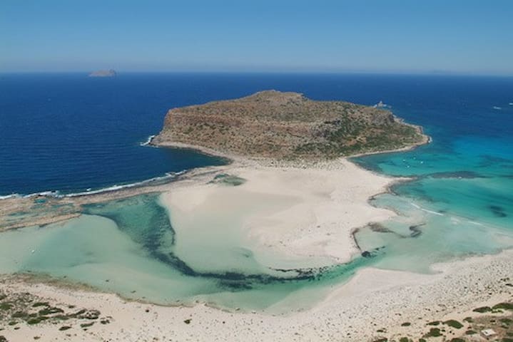
Spiaggia di Balos
Must visit beach in the area of Kissamos, 40 km west from ¨Sea and Sun¨. The lagoon known as Balos beach is located on the northwestern side of Chania in the region known as Kissamos. You can get there by car (you will need to walk about 15 min) or by boat from the harbor of Kisamos.
It is a beautiful exotic landscape with pink sand (64 km southwest from Sea and Sun). Elafonisi (or Elafonissos) is a small islet connected to the rest of Crete by a shallow reef that can be crossed when the sea is calm. This islet can be reached by boat from Paleohora or by car from the village of Vathi, until a point and then cross the reef. Natural landscape of the protected plant species Cedrus libani.
442 persone del luogo consigliano
Spiaggia di Elafonissi
It is a beautiful exotic landscape with pink sand (64 km southwest from Sea and Sun). Elafonisi (or Elafonissos) is a small islet connected to the rest of Crete by a shallow reef that can be crossed when the sea is calm. This islet can be reached by boat from Paleohora or by car from the village of Vathi, until a point and then cross the reef. Natural landscape of the protected plant species Cedrus libani.
(64 km southwest from Sea and Sun). Aspri Limni (i.e. White Lake) is one of the most weird beaches in Crete, that almost nobody knows. This is a small secret beach, located 500m west of Chrysoskalitissa monastery and 70km southwest of Chania city. Thousands of visitors are attracted by the nearby exotic Elafonissi lagoon, but actually nobody has heard of this magnificent neighboring place.
The beach has fine white sand and rocks in places and is surrounded by sharp rocks, reminding of a small whitish lake inside the sea. Fortunately, the beach is unexploited by touristic industry and remains an untouched paradise. There is no natural shade in the area.
In order to come here, you have to turn right in Chrysoskalitissa village and follow the signs to the small Phoenix theofrasti (Cretan palm date) habitat, located around the lake. Otherwise, just ask one local to show you the way.
Aspri Limni is a Natura 2000 protected area because it is the westernmost habitat of Phoenix theofrasti, the endangered palm tree of Crete. The palm species is also met in other palm groves of Crete such as Vai, Preveli, Agios Nikitas, Souda, etc, but also small colonies exist in South Turkey. Among them, the palm grove in Vai is the largest.
Πηγή: ⭐ Travel Guide for Island Crete ⛵, Greece❗ - Aspri Limni beach cretanbeaches.com
https://www.cretanbeaches.com/en/sea-tourism/west-crete-beaches/aspri-limni-beach
6 persone del luogo consigliano
Aspri Limni
(64 km southwest from Sea and Sun). Aspri Limni (i.e. White Lake) is one of the most weird beaches in Crete, that almost nobody knows. This is a small secret beach, located 500m west of Chrysoskalitissa monastery and 70km southwest of Chania city. Thousands of visitors are attracted by the nearby exotic Elafonissi lagoon, but actually nobody has heard of this magnificent neighboring place.
The beach has fine white sand and rocks in places and is surrounded by sharp rocks, reminding of a small whitish lake inside the sea. Fortunately, the beach is unexploited by touristic industry and remains an untouched paradise. There is no natural shade in the area.
In order to come here, you have to turn right in Chrysoskalitissa village and follow the signs to the small Phoenix theofrasti (Cretan palm date) habitat, located around the lake. Otherwise, just ask one local to show you the way.
Aspri Limni is a Natura 2000 protected area because it is the westernmost habitat of Phoenix theofrasti, the endangered palm tree of Crete. The palm species is also met in other palm groves of Crete such as Vai, Preveli, Agios Nikitas, Souda, etc, but also small colonies exist in South Turkey. Among them, the palm grove in Vai is the largest.
Πηγή: ⭐ Travel Guide for Island Crete ⛵, Greece❗ - Aspri Limni beach cretanbeaches.com
https://www.cretanbeaches.com/en/sea-tourism/west-crete-beaches/aspri-limni-beach
(50 km from Sea and Sun) Lake Kournas is the largest natural lake in Crete and is located in an enchanting landscape, between the west slopes of the White Mountains and the fertile plane of Georgioupolis. It is located near the village Kournas, 2.5km south of the beach of Georgioupolis, 43km east of Chania and 20km west of Rethymnon. Lake Kournas and its surroundings constitute a very important ecosystem for Greece, as the wider area of Apokoronas is one of the very few areas of Crete where plenty of fresh water is stored throughout the year.
The name Kournas is believed to come from the Arabic word kurna for "lake" or "bath". In ancient manuscripts it is mentioned as Korissia, while it is believed that the area hosted a sanctuary dedicated to Korissia Athena.
The lake is created by the accumulation of groundwater coming from the White Mountains. The water gushes from a spring called Amati or Mati (meaning “eye”), which is over the lake surface in the summer months, while it’s hidden below the surface during winter. There is a second spring, which is always underneath the surface. Essentially, Kournas Lake is a large pit that is fed from its southeastern side by water due to the porous grounds, while from the opposite site it is waterproofed due to the nature of the rocks.
The lake is small and circular and covers an area of 57.9 hectares, has maximum depth 22.5 m, maximum length 1080m and maximum width of 880m. The volume of water in summer is approximately 7.5 million cubic meters. The water is transported to the beach of Kavros via the river Delfinas. In some parts of the lake, overflow and drainage works can be seen, that are used for diverting water to the farmland.
Πηγή: ⭐ Travel Guide for Island Crete ⛵, Greece❗ - Lake Kournas cretanbeaches.com
https://www.cretanbea
17 persone del luogo consigliano
Lago Kourna
(50 km from Sea and Sun) Lake Kournas is the largest natural lake in Crete and is located in an enchanting landscape, between the west slopes of the White Mountains and the fertile plane of Georgioupolis. It is located near the village Kournas, 2.5km south of the beach of Georgioupolis, 43km east of Chania and 20km west of Rethymnon. Lake Kournas and its surroundings constitute a very important ecosystem for Greece, as the wider area of Apokoronas is one of the very few areas of Crete where plenty of fresh water is stored throughout the year.
The name Kournas is believed to come from the Arabic word kurna for "lake" or "bath". In ancient manuscripts it is mentioned as Korissia, while it is believed that the area hosted a sanctuary dedicated to Korissia Athena.
The lake is created by the accumulation of groundwater coming from the White Mountains. The water gushes from a spring called Amati or Mati (meaning “eye”), which is over the lake surface in the summer months, while it’s hidden below the surface during winter. There is a second spring, which is always underneath the surface. Essentially, Kournas Lake is a large pit that is fed from its southeastern side by water due to the porous grounds, while from the opposite site it is waterproofed due to the nature of the rocks.
The lake is small and circular and covers an area of 57.9 hectares, has maximum depth 22.5 m, maximum length 1080m and maximum width of 880m. The volume of water in summer is approximately 7.5 million cubic meters. The water is transported to the beach of Kavros via the river Delfinas. In some parts of the lake, overflow and drainage works can be seen, that are used for diverting water to the farmland.
Πηγή: ⭐ Travel Guide for Island Crete ⛵, Greece❗ - Lake Kournas cretanbeaches.com
https://www.cretanbea
(50km west from Sea and Sun) The exotic beach of Falassarna is located at the western base of peninsula Gramvousa. At the northern end of the beach there are the ruins of the ancient Grecoroman city of Phalassarna.
Falassarna bay hosts some of the most famous beaches in Greece, which has been awarded as the best beach of Crete and voted as one of the 10 best beaches in Europe several times in the past. Falasarna spans a large area and consists actually of five consecutive beaches, with the two most central being the most favorite.
The sand in Falassarna is whitish, making the water color tropical. Indeed, if you're lucky and be here on a day that is not blowing from the west (rare in west Crete) you will be enchanted by the beach and its turquoise waters.
The main beach of Falassarna is called Pachia Ammos (i..e Coarse Sand). It is an exotic beach with a length of 1km and a width of 150m. This beach attracts the most visitors of the area, but because of its length it never seems too crowded. The beach offers umbrellas and a few snack bars and cafes, where you can get food and water. There are also services for water sports and beach volley courts.
There is another long beach north of the main beach having a length of 800m, identical to the main beach, which is separated into several smaller beaches. This bay is divided in half by a sand dune and a few rocks. The beach is more quiet than Pachia Ammos and offers no facilities. Nearby, there is the chapel of Agia Paraskevi and a spring with fresh water.
Further north, near the archaeological site, there is a small cove facing to the south. It is pebbly and the seabed is rocky. It is a good choice when the winds blow from west or you seek isolation. South of Pachia Ammos, at Livadi, there is another long beach that has sandy shore and rocky seabed. It is a very good choice for fans of the snorkelling. Livadi is surrounded by a very important wetland with ponds, which host many birds in winter. Even southern, near the small harbor of Limeniskos settlement there is a small pebbly beach, which is a good choice if you do not want to stay remote.
The area around Falassarna is magnificent and is a protected nature reserve. If you have time and are looking for something romantic, you can wait for the sunset, which is considered the best in Crete. How could this not be the best, when being in such an amazing landscape and there is no obstacle between the beach the horizon? When it gets dark, you might be lucky to visit one of the several beach partys organized in Falassarna during summer.
One drawback about Falasarna is that it looks west and is usually wavy. However, this is desired by windsurfers. There are also reports that the surrounding greenhouses pollute the sea with fertilizers and trash, which, if being true, is a real shame. If you do not have a mean to get in Falassarna, you can catch the bus from Chania or Kissamos.
Ancient Falassarna or Korykos was the main port of the Polyrinia and flourished in the 4th and 3rd centuries BC. The ruins of Polyrinia are located 6km south of Kissamos. It is named after the local nymph Falassarni. Falasarna had its own coin, with a woman on one side and the letters ΦΑ to the other. In the ruined city, north of the beach, you can still see the city walls, ruins of the acropolis, remains of houses, ancient tombs and a stone throne, which is believed that was dedicated to the God of the Sea, Poseidon. Today, the ancient port are located on the shore, probably to the elevation of 6-9 m caused by the strong earthquake of 365 AD. Also, a part of the city seems to be immersed in the sea.
Πηγή: ⭐ Travel Guide for Island Crete ⛵, Greece❗ - Falassarna Beach cretanbeaches
369 persone del luogo consigliano
Phalasarna
(50km west from Sea and Sun) The exotic beach of Falassarna is located at the western base of peninsula Gramvousa. At the northern end of the beach there are the ruins of the ancient Grecoroman city of Phalassarna.
Falassarna bay hosts some of the most famous beaches in Greece, which has been awarded as the best beach of Crete and voted as one of the 10 best beaches in Europe several times in the past. Falasarna spans a large area and consists actually of five consecutive beaches, with the two most central being the most favorite.
The sand in Falassarna is whitish, making the water color tropical. Indeed, if you're lucky and be here on a day that is not blowing from the west (rare in west Crete) you will be enchanted by the beach and its turquoise waters.
The main beach of Falassarna is called Pachia Ammos (i..e Coarse Sand). It is an exotic beach with a length of 1km and a width of 150m. This beach attracts the most visitors of the area, but because of its length it never seems too crowded. The beach offers umbrellas and a few snack bars and cafes, where you can get food and water. There are also services for water sports and beach volley courts.
There is another long beach north of the main beach having a length of 800m, identical to the main beach, which is separated into several smaller beaches. This bay is divided in half by a sand dune and a few rocks. The beach is more quiet than Pachia Ammos and offers no facilities. Nearby, there is the chapel of Agia Paraskevi and a spring with fresh water.
Further north, near the archaeological site, there is a small cove facing to the south. It is pebbly and the seabed is rocky. It is a good choice when the winds blow from west or you seek isolation. South of Pachia Ammos, at Livadi, there is another long beach that has sandy shore and rocky seabed. It is a very good choice for fans of the snorkelling. Livadi is surrounded by a very important wetland with ponds, which host many birds in winter. Even southern, near the small harbor of Limeniskos settlement there is a small pebbly beach, which is a good choice if you do not want to stay remote.
The area around Falassarna is magnificent and is a protected nature reserve. If you have time and are looking for something romantic, you can wait for the sunset, which is considered the best in Crete. How could this not be the best, when being in such an amazing landscape and there is no obstacle between the beach the horizon? When it gets dark, you might be lucky to visit one of the several beach partys organized in Falassarna during summer.
One drawback about Falasarna is that it looks west and is usually wavy. However, this is desired by windsurfers. There are also reports that the surrounding greenhouses pollute the sea with fertilizers and trash, which, if being true, is a real shame. If you do not have a mean to get in Falassarna, you can catch the bus from Chania or Kissamos.
Ancient Falassarna or Korykos was the main port of the Polyrinia and flourished in the 4th and 3rd centuries BC. The ruins of Polyrinia are located 6km south of Kissamos. It is named after the local nymph Falassarni. Falasarna had its own coin, with a woman on one side and the letters ΦΑ to the other. In the ruined city, north of the beach, you can still see the city walls, ruins of the acropolis, remains of houses, ancient tombs and a stone throne, which is believed that was dedicated to the God of the Sea, Poseidon. Today, the ancient port are located on the shore, probably to the elevation of 6-9 m caused by the strong earthquake of 365 AD. Also, a part of the city seems to be immersed in the sea.
Πηγή: ⭐ Travel Guide for Island Crete ⛵, Greece❗ - Falassarna Beach cretanbeaches
(25 km north east from Agia Marina) Stavros (i.e. cross) is a seaside village located 17km northeast of Chania, at the northernmost edge of Cape Akrotiri. One characteristic feature of the area is the very steep camel-shaped mountain Vardies rising opposite the harbor of Stavros. The mountain is famous, because there were filmed scenes for the film “Zorba the Greek”, where Anthony Quinn danced the famous Sirtaki Dance in 1964. Then Stavros was a humble small fishing village. Today the region has become a major tourist resort with many hotels and important tourist infrastructures. The two beautiful beaches of the area have contributed to the development of the area. The main beach is located east of the village, at the foot of the mountain Vardies, and next to the picturesque harbor. A semicircular lagoon is formed, fully protected by winds blowing in the region. The small bay has marvelous white sand and shallow turquoise water. The contrast of the wild mountain with the peaceful beach in the foreground makes Stavros a unique place for swimming. As expected, the beach is very well organized and provides all possible services. The second beach of Stavros is located north of the village, 200m northwest of the main beach. It has sand and rocks in places and is less organized than the first, but cleaner. The main drawback of this is that it is unprotected and the sea is usually wavy. At the peninsula dividing the two beaches of Stavros, you can see the remains of the ancient quarry, used for extracting limestone for building the Walls of Chania during the Venetian Era (13rd- 17th century).
Πηγή: ⭐ Travel Guide for Island Crete ⛵, Greece❗ - Stavros Beach cretanbeaches.com
125 persone del luogo consigliano
Spiaggia di Stavros
(25 km north east from Agia Marina) Stavros (i.e. cross) is a seaside village located 17km northeast of Chania, at the northernmost edge of Cape Akrotiri. One characteristic feature of the area is the very steep camel-shaped mountain Vardies rising opposite the harbor of Stavros. The mountain is famous, because there were filmed scenes for the film “Zorba the Greek”, where Anthony Quinn danced the famous Sirtaki Dance in 1964. Then Stavros was a humble small fishing village. Today the region has become a major tourist resort with many hotels and important tourist infrastructures. The two beautiful beaches of the area have contributed to the development of the area. The main beach is located east of the village, at the foot of the mountain Vardies, and next to the picturesque harbor. A semicircular lagoon is formed, fully protected by winds blowing in the region. The small bay has marvelous white sand and shallow turquoise water. The contrast of the wild mountain with the peaceful beach in the foreground makes Stavros a unique place for swimming. As expected, the beach is very well organized and provides all possible services. The second beach of Stavros is located north of the village, 200m northwest of the main beach. It has sand and rocks in places and is less organized than the first, but cleaner. The main drawback of this is that it is unprotected and the sea is usually wavy. At the peninsula dividing the two beaches of Stavros, you can see the remains of the ancient quarry, used for extracting limestone for building the Walls of Chania during the Venetian Era (13rd- 17th century).
Πηγή: ⭐ Travel Guide for Island Crete ⛵, Greece❗ - Stavros Beach cretanbeaches.com
Natural landscapes of exceptional beauty
(43 km south from Sea and Sun). The Samaria Gorge is the most famous trekking gorge in Europe and a part of the European E4 hiking trail. Thousands of tourists flock here daily in the summer season to walk from the top to the bottom. For many visitors, it is the sole purpose of their visit to Crete. The length of the gorge reaches 14.5km and takes almost 5-7 hours to hike from Xyloskalo at Omalos plateau to Agia Roumeli beach, depending on the trekking pace.
The gorge is locarted at the south of Chania Prefecture in the larger uninhabited area of Europe, where no roads even exist. It was created by the river flowing between the main massif of the White Mountains (Lefka Ori) and the range of Volakias. There are many smaller gorges vertical to Samaria Gorge, some of which have never been crossed by humans and require canyoning equipment. One of these, Perdika, has the highest waterfall in Crete (220m).
Πηγή: ⭐ Travel Guide for Island Crete ⛵, Greece❗ - Samaria Gorge cretanbeaches.com
https://www.cretanbeaches.com/en/gorges-and-canyons-in-crete/west-crete-gorges-chania/samaria-gorge
517 persone del luogo consigliano
Gola di Samaria
(43 km south from Sea and Sun). The Samaria Gorge is the most famous trekking gorge in Europe and a part of the European E4 hiking trail. Thousands of tourists flock here daily in the summer season to walk from the top to the bottom. For many visitors, it is the sole purpose of their visit to Crete. The length of the gorge reaches 14.5km and takes almost 5-7 hours to hike from Xyloskalo at Omalos plateau to Agia Roumeli beach, depending on the trekking pace.
The gorge is locarted at the south of Chania Prefecture in the larger uninhabited area of Europe, where no roads even exist. It was created by the river flowing between the main massif of the White Mountains (Lefka Ori) and the range of Volakias. There are many smaller gorges vertical to Samaria Gorge, some of which have never been crossed by humans and require canyoning equipment. One of these, Perdika, has the highest waterfall in Crete (220m).
Πηγή: ⭐ Travel Guide for Island Crete ⛵, Greece❗ - Samaria Gorge cretanbeaches.com
https://www.cretanbeaches.com/en/gorges-and-canyons-in-crete/west-crete-gorges-chania/samaria-gorge
(44 km south of Sea and Sun). The gorge is part of the European path E4. It’s south entrance is located 5 kilometers north of Sougia. It is part of the NATURA 2000 program and has also been designated as a wildlife sanctuary by the Ministry of Agriculture. The gorge hosts the endangered Cretan wild goat and is characterized by a variety of microenvironments that habitat for many species of wildlife.
HTTPS://WWW.CRETANBEACHES.COM
26 persone del luogo consigliano
Agia Irini Gorge
(44 km south of Sea and Sun). The gorge is part of the European path E4. It’s south entrance is located 5 kilometers north of Sougia. It is part of the NATURA 2000 program and has also been designated as a wildlife sanctuary by the Ministry of Agriculture. The gorge hosts the endangered Cretan wild goat and is characterized by a variety of microenvironments that habitat for many species of wildlife.
HTTPS://WWW.CRETANBEACHES.COM
(22 km south east of Sea and Sun) The Gorge of Therisso (named also Eleftherios Venizelos) is located near the city of Chania. You can go there by car. The main gorge is six kilometers long. The vertical cliffs are impressive and the lush vegetation has nothing to envy of the other Chania Gorges. The place deserves a visit, even with a vehicle, cobined with a visit in the historical beautiful village of Therisso, that is built at the foot of the White Mountains at an altitude of 580 meters, just 15 kilometers from the city of Chania. A visit here is something that will remain unforgettable to every visitor.
The known-heroic Theriso village belongs to the province Kydonia and has more than 100 residents. The place played a crucial role in the modern history of Crete since the residents have not stopped fighting to the Turks, who repeatedly tried to break the resistance of this strong position. In 1866 the Theriso was burned by Mustapha Pasha Naili and many people- including the mother of of the later prime minister of Greece, Eleftherios Venizelos, moved in Kythera and the Peloponnese. The historic village acquired greater importance during the events of 1905, when Eleftherios Venizelos and his followers declared from here the revolution against the autocratic regime of Prince George-who were was imposed by the Great Powers- paving the of Crete with Greece. Brothers Halides, heroes of 1821, come also from Theriso.
Πηγή: ⭐ Travel Guide for Island Crete ⛵, Greece❗ - Therisso Gorge cretanbeaches.com
https://www.cretanbeaches.com/en/gorges-and-canyons-in-crete/west-crete-gorges-chania/therisso-gorge-eleftherios-venizelos
32 persone del luogo consigliano
Therisos gorge
Vasiliou Poulaka(22 km south east of Sea and Sun) The Gorge of Therisso (named also Eleftherios Venizelos) is located near the city of Chania. You can go there by car. The main gorge is six kilometers long. The vertical cliffs are impressive and the lush vegetation has nothing to envy of the other Chania Gorges. The place deserves a visit, even with a vehicle, cobined with a visit in the historical beautiful village of Therisso, that is built at the foot of the White Mountains at an altitude of 580 meters, just 15 kilometers from the city of Chania. A visit here is something that will remain unforgettable to every visitor.
The known-heroic Theriso village belongs to the province Kydonia and has more than 100 residents. The place played a crucial role in the modern history of Crete since the residents have not stopped fighting to the Turks, who repeatedly tried to break the resistance of this strong position. In 1866 the Theriso was burned by Mustapha Pasha Naili and many people- including the mother of of the later prime minister of Greece, Eleftherios Venizelos, moved in Kythera and the Peloponnese. The historic village acquired greater importance during the events of 1905, when Eleftherios Venizelos and his followers declared from here the revolution against the autocratic regime of Prince George-who were was imposed by the Great Powers- paving the of Crete with Greece. Brothers Halides, heroes of 1821, come also from Theriso.
Πηγή: ⭐ Travel Guide for Island Crete ⛵, Greece❗ - Therisso Gorge cretanbeaches.com
https://www.cretanbeaches.com/en/gorges-and-canyons-in-crete/west-crete-gorges-chania/therisso-gorge-eleftherios-venizelos
Φαγητό
(1,2 km from Sea and Sun) Enjoy your meal, your drink or soft drink by the beautiful sea of Agia Marina. Delicious food, beautiful beaach.
10 persone del luogo consigliano
Almira Beach Bar Restaurant Chania
Αγίας Μαρίνας(1,2 km from Sea and Sun) Enjoy your meal, your drink or soft drink by the beautiful sea of Agia Marina. Delicious food, beautiful beaach.
Chrisostomos
και Ikarou(11 km from Sea and Sun) Delicious traditional food!
Delicious Mediterranean, Greek, European cuisines.
Just a short walk from Sea and Sun
Raeti Taverna Restaurant
Delicious Mediterranean, Greek, European cuisines.
Just a short walk from Sea and Sun
Beach bars
Red Havana
45 PEO Kissamou Chanion(750 metres from Sea and Sun) Beach bar , bar restaurant, kids area, pool, dinner!
(120 metres from Sea and Sun). Beach bar on the beautiful sandy beach of Agia Marina. Enjoy the sea , while sipping your ice coffee, cocktail or beer or enjoy your meal!
Rodakino Beach Bar
(120 metres from Sea and Sun). Beach bar on the beautiful sandy beach of Agia Marina. Enjoy the sea , while sipping your ice coffee, cocktail or beer or enjoy your meal!
(700 metres from Sea and Sun) Beautiful beach bar. Enjoy your coffee, drink or meal.
93 persone del luogo consigliano
Cabana Mare Beach Resort
(700 metres from Sea and Sun) Beautiful beach bar. Enjoy your coffee, drink or meal.