
Cristina's Guidebook
Sightseeing
A stunning area for volcanic rock formations. The park is located in the scenic Chihuahuan desert region of Southwest NM. The “city” is a geologic formation made up of large, sculptured rock columns, or pinnacles, rising as high as 40 feet and separated by paths or lanes resembling city streets. These rocks were formed when a very large volcano erupted. Located about halfway between Silver City and Deming, City of Rocks offers camp sites, hiking trails, excellent mountain biking, wildlife viewing, birding, stargazing, picnic areas and a desert botanical garden.
29 persone del luogo consigliano
Parco Statale City of Rocks
327 NM-61A stunning area for volcanic rock formations. The park is located in the scenic Chihuahuan desert region of Southwest NM. The “city” is a geologic formation made up of large, sculptured rock columns, or pinnacles, rising as high as 40 feet and separated by paths or lanes resembling city streets. These rocks were formed when a very large volcano erupted. Located about halfway between Silver City and Deming, City of Rocks offers camp sites, hiking trails, excellent mountain biking, wildlife viewing, birding, stargazing, picnic areas and a desert botanical garden.
The trail offers a fascinating glimpse into the geologic and historic foundations of southwest New Mexico. The result of cataclysmic volcanic actions, the area now offers a beautiful picnic spot next to Whitewater Creek, a challenging one-mile trail along the historic 1890's mining waterway, and a sense of place that creates images of an earlier time.
21 persone del luogo consigliano
Catwalk Recreation Area
The trail offers a fascinating glimpse into the geologic and historic foundations of southwest New Mexico. The result of cataclysmic volcanic actions, the area now offers a beautiful picnic spot next to Whitewater Creek, a challenging one-mile trail along the historic 1890's mining waterway, and a sense of place that creates images of an earlier time.
Ancient, interlinked dwellings built in alcoves in a very remote canyon, deep in the Gila Wilderness. Nearby are several hot springs and a network of trails through the steep, wooded surroundings.
46 persone del luogo consigliano
Gila Cliff Dwellings National Monument
26 Jim Bradford Trail
Ancient, interlinked dwellings built in alcoves in a very remote canyon, deep in the Gila Wilderness. Nearby are several hot springs and a network of trails through the steep, wooded surroundings.
Gila Hot Springs
Great area for day soaks, hiking, fishing, and sightseeing.
Pinos Altos is a small community located just about 5 miles north of Silver City. It was a mining town and Grant County's first county seat, formed in 1860 following the discovery of gold in the nearby Pinos Altos Mountains. Drive up the hill from Silver City to see this charming little town rich in history. You will feel like you just stepped into the old west.
8 persone del luogo consigliano
Pinos Altos
Pinos Altos is a small community located just about 5 miles north of Silver City. It was a mining town and Grant County's first county seat, formed in 1860 following the discovery of gold in the nearby Pinos Altos Mountains. Drive up the hill from Silver City to see this charming little town rich in history. You will feel like you just stepped into the old west.
Faywood Hot Springs, are thermal springs in Grant County, New Mexico, United States. It is located 2 miles northeast of US 180 and .5 miles west of NM 61, just south of the City of Rocks State Park. The hot springs have been visited since the time of the Mimbres culture
13 persone del luogo consigliano
Faywood Hot Springs
165 NM-61Faywood Hot Springs, are thermal springs in Grant County, New Mexico, United States. It is located 2 miles northeast of US 180 and .5 miles west of NM 61, just south of the City of Rocks State Park. The hot springs have been visited since the time of the Mimbres culture
Food Scene
Great food and drinks with a lot of personality.
23 persone del luogo consigliano
Little Toad Creek Brewery & Distillery
200 N Bullard StGreat food and drinks with a lot of personality.
Jalisco Cafe
103 S Bullard StAuthentic Mexican Food
A tasty stop for sweets, treats, soups, salads and meals ready to go!
6 persone del luogo consigliano
Diane’s Bakery and Deli
601 N Bullard StA tasty stop for sweets, treats, soups, salads and meals ready to go!
The Ice Cream Emporium
312 N Bullard StDelicious assortment of ice cream and more.
You feel right at home in thia historic bar and opera house. Warm atmosphere and live music. Musicians from all over love to play here because of the great audiences and intimate venue. Steakhouse style meals and house specials.
17 persone del luogo consigliano
Buckhorn Saloon & Opera House
32 Main StYou feel right at home in thia historic bar and opera house. Warm atmosphere and live music. Musicians from all over love to play here because of the great audiences and intimate venue. Steakhouse style meals and house specials.
Burgers, Sandwiches, Salads, Breakfast...you name it...they have it.
9 persone del luogo consigliano
Adobe Springs Cafe
614 N Bullard StBurgers, Sandwiches, Salads, Breakfast...you name it...they have it.
Small intimate restaurant , that uses local and regional ingredients to make the freshest food possible, with prohabition themed spirits to go with your meals.
Mick's 33's Lounge
101 West College AvenueSmall intimate restaurant , that uses local and regional ingredients to make the freshest food possible, with prohabition themed spirits to go with your meals.
Don Juan's Burritos & Mexican Food
418 Silver Heights BlvdLocal fave for a quick and delicious burrito.
Hiking
Dragonfly Trail Pictographs
Dragonfly TrailGreat day hiking spots minutes away from town.
This is an easy scenic walk through pinon juniper setting and rolling plains. The Big Juniper Tree is nationally ranked as the second largest alligator Juniper Tree. Its diameter is 70.2 in, circumference is 18 ft. 4 in, crown spread is 62 feet., and height is 63 feet. The Big Juniper Tree is located on lands previously utilized as part of the historic Fort Bayard Military Reservation. The route to the Big Juniper Tree follows primitive roads that pass through the rolling foothills of the Pinos Altos Mountains which lie to the north. It is recommended to take a picture or study the map at the trailhead if it is your hike at this location. It connects eith several other trails in the area.
Fort Bayard Big Tree Trail
Fort Bayard RoadThis is an easy scenic walk through pinon juniper setting and rolling plains. The Big Juniper Tree is nationally ranked as the second largest alligator Juniper Tree. Its diameter is 70.2 in, circumference is 18 ft. 4 in, crown spread is 62 feet., and height is 63 feet. The Big Juniper Tree is located on lands previously utilized as part of the historic Fort Bayard Military Reservation. The route to the Big Juniper Tree follows primitive roads that pass through the rolling foothills of the Pinos Altos Mountains which lie to the north. It is recommended to take a picture or study the map at the trailhead if it is your hike at this location. It connects eith several other trails in the area.
Located just past Pinos Altos on the right as you enter National Forest. You can hike for as little or as much using this trail. Begin at the Arrastre Site trailhead. This is the start of Segment 8 of the New Mexico section of the CDT. At first, the trail follows an old mining road and then venture as far as you are prepared for. For longer hikes prepare well and have a map on hand as many trails can connect. Enjoy!
Arrastra Interpretive Site
Located just past Pinos Altos on the right as you enter National Forest. You can hike for as little or as much using this trail. Begin at the Arrastre Site trailhead. This is the start of Segment 8 of the New Mexico section of the CDT. At first, the trail follows an old mining road and then venture as far as you are prepared for. For longer hikes prepare well and have a map on hand as many trails can connect. Enjoy!
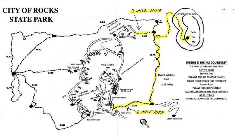
Table Mountain Trail is a 5.1 mile lightly trafficked out and back trail located near Faywood, New Mexico that offers the chance to see wildlife and is rated as moderate. The trail is primarily used for hiking and running.
Hydra Trail is a 3.6 mile lightly trafficked loop trail located near Faywood, New Mexico and is good for all skill levels. The trail offers a number of activity options.
City of Rocks
City of RocksTable Mountain Trail is a 5.1 mile lightly trafficked out and back trail located near Faywood, New Mexico that offers the chance to see wildlife and is rated as moderate. The trail is primarily used for hiking and running.
Hydra Trail is a 3.6 mile lightly trafficked loop trail located near Faywood, New Mexico and is good for all skill levels. The trail offers a number of activity options.
Easy hiking close to town. Connects with Continental Divide Trail and othwr forest trails.
Gomez Peak Trail
Gomez Peak TrailEasy hiking close to town. Connects with Continental Divide Trail and othwr forest trails.
Pet Friendly Places
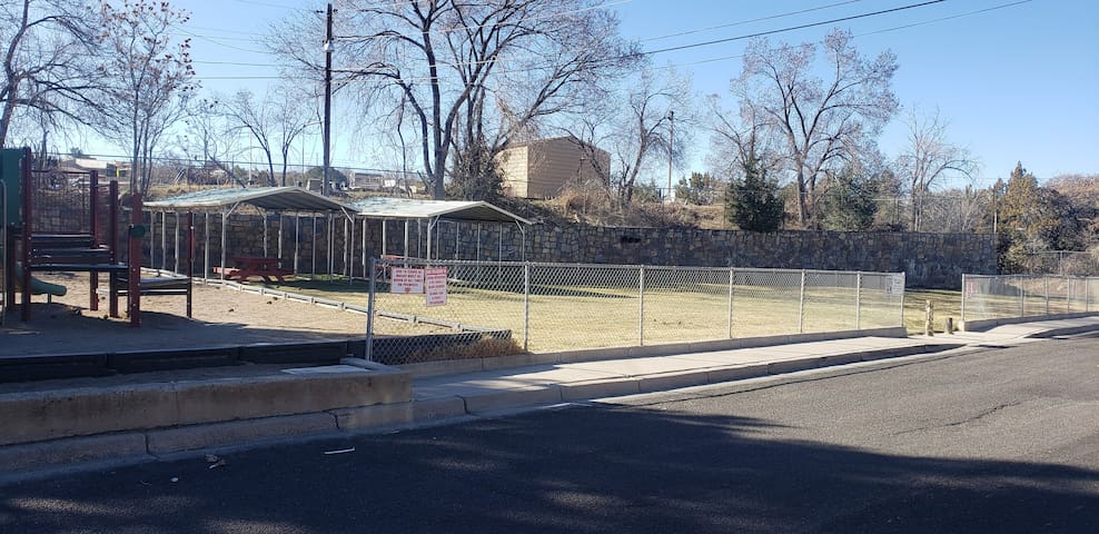
Silver City Dog Park
1200-1298 N Virginia StGreat fenced in area for your pup to run and play. Clean and open grassy area.
Corner of N Kimberly Drive & E Valle Drive. Hidden gem tucked away in the center of town. Take your family and dog for a picnic and some fun at the park.
Kimberly Drive
Kimberly DriveCorner of N Kimberly Drive & E Valle Drive. Hidden gem tucked away in the center of town. Take your family and dog for a picnic and some fun at the park.
Fishing
Bill Evans Lake is a reservoir located about 18.2 miles from Silver City. There are a variety of fish including rainbow trout, flathead catfish, perch, largemouth bass, crappie, catfish and smallmouth bass here. When you are ready for some fresh air and fun in the sun grab your favorite fishing rod and reel, and head out to Bills Evans.
Bill Evans Lake
Bill Evans Lake is a reservoir located about 18.2 miles from Silver City. There are a variety of fish including rainbow trout, flathead catfish, perch, largemouth bass, crappie, catfish and smallmouth bass here. When you are ready for some fresh air and fun in the sun grab your favorite fishing rod and reel, and head out to Bills Evans.
Our beautiful Lake Roberts is located in the Wilderness Ranger District along NM 35 about 43 miles from our location which takes about an hour driving through our breath-taking Mimbres Valley and mountains. It is dedicated and named after Austin Robert, a US Forest Service pilot who was killed on January 4th, 1960 when the plane he was flying to do a hay drop to starving deer in the winter, crashed into the side of a mountain that was hidden by a cloud.
Although probably not the main pilot, it is thought that he was co-pilot of the plane that flew Smokey Bear from Cloudcroft area to Washington DC to become the national mascot for fire safety.
10 persone del luogo consigliano
Lake Roberts
Our beautiful Lake Roberts is located in the Wilderness Ranger District along NM 35 about 43 miles from our location which takes about an hour driving through our breath-taking Mimbres Valley and mountains. It is dedicated and named after Austin Robert, a US Forest Service pilot who was killed on January 4th, 1960 when the plane he was flying to do a hay drop to starving deer in the winter, crashed into the side of a mountain that was hidden by a cloud.
Although probably not the main pilot, it is thought that he was co-pilot of the plane that flew Smokey Bear from Cloudcroft area to Washington DC to become the national mascot for fire safety.
Come enjoy this quiet little spot to spend the day fishing. The centerpiece of Bear Canyon Wildlife Area is Bear Canyon Reservoir, a 25-acre lake in Grant County. Access is via Highway 35, northeast of Silver City. The wildlife area is about 75 acres.
This small property provides fishing access and habitat for wildlife. The reservoir is located in a steep-sided rocky canyon on the Mimbres River. It sits at 6,000 feet in elevation and is
surrounded by pinon, juniper, and oak vegetation.
Bear Canyon Reservoir
Come enjoy this quiet little spot to spend the day fishing. The centerpiece of Bear Canyon Wildlife Area is Bear Canyon Reservoir, a 25-acre lake in Grant County. Access is via Highway 35, northeast of Silver City. The wildlife area is about 75 acres.
This small property provides fishing access and habitat for wildlife. The reservoir is located in a steep-sided rocky canyon on the Mimbres River. It sits at 6,000 feet in elevation and is
surrounded by pinon, juniper, and oak vegetation.
Information & Visitor Centers
Visitor Center
201 N Hudson StA great place to stop and get maps, information and so much more!
Groceries
Our local food coop stocked full of healthy foods and supplements.
12 persone del luogo consigliano
The Silver City Food Co-op
520 N Bullard StOur local food coop stocked full of healthy foods and supplements.
Albertsons
1956 US-180Local grocery
Walmart Supercenter
2501 U.S. 180One stop shop for your personal and grocery needs.
Food Basket
1220 N Hudson StGreat chicken strips!