
BlackSands: A Guide to Discovering Shelter Cove
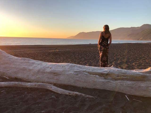
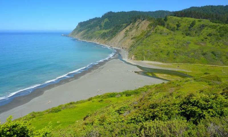
Black Sands Beach
The walk to Black Sands beach is about .5 miles and 300 feet of elevation. It takes 10 min on the way down and 20 coming back to the house. You can also drive and there is parking in the main lot with a bathroom or just to the left of the entrance.Black Sands Beach is the south end of a long walkable coastline that is over 20 miles long between Shelter Cove to Mattole River Campground. The Lost Coast Trail takes backpackers north on this beach to numerous wilderness camp spots and remote places. Parts of this stretch are blocked at high tide so plan accordingly if you are backpacking. Day-use of the wide dark sand and pebbly beach near the parking lot is nearly ideal. You can walk either direction on the beach. To the north is a great vast beachcombing shoreline and to the south is Little Black Sands Beach. This entire area is protected by the Bureau of Land Management in the King Range National Conservation Area.
Black Sand Beach is located at the end of Beach Road. There is a parking lot just on the right before at the end of Beach. There are restrooms in the parking lot. There is handicap parking if you continue down toward the beach.
There is a dirt trail that leads past a small creek to the beach. You will see a huge boulder that is fun to clime and watch the waves
Bring your beach chairs and a blanket to watch the sunset. This isn’t a swimming beach, as the waves are shore breakers and usually pretty powerful. You can walk for miles on this beach as it is the start of the almost Coast trail, one of the most famous coastal backpacking trips in the US. This is awe inspiring nature!
9 persone del luogo consigliano
Black Sands Beach
Black Sand Beach is located at the end of Beach Road. There is a parking lot just on the right before at the end of Beach. There are restrooms in the parking lot. There is handicap parking if you continue down toward the beach.
There is a dirt trail that leads past a small creek to the beach. You will see a huge boulder that is fun to clime and watch the waves
Bring your beach chairs and a blanket to watch the sunset. This isn’t a swimming beach, as the waves are shore breakers and usually pretty powerful. You can walk for miles on this beach as it is the start of the almost Coast trail, one of the most famous coastal backpacking trips in the US. This is awe inspiring nature!
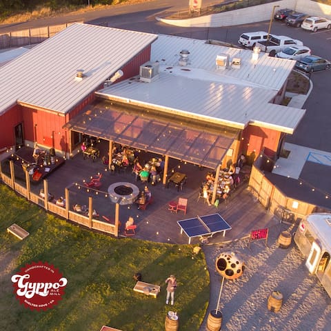
Gyppos- our favorite brewery and restaurant
Gyppos is one of our favorite restaurants! They are located on the south end of the airport runway.
BREWERY, RESTAURANT & BEER GARDEN
What does the edge of the world look like? It looks like the Lost Coast of California and that is just where you will find the Gyppo Ale Mill. We are located along the longest stretch of coastal wilderness in the lower 48! We fancy ourselves “California’s Most Remote Brewery” but we are that and much more. Yes, we have award winning kick ass beers! Head Brewer, Jared Smith has a continuous rotation of delicious and quaffable beers. TWELVE beers on tap in the restaurant and FOUR on tap in BeerSTREAM, a converted Airstream trailer in our beer garden. And YES, our seasonal, sustainable sourced menu will having you coming back for more. Everyone one of Chef Robert Mason dishes are created from scratch with an extreme attention to details. But what more is there you ask?
1661 Upper Pacific Dr
1661 Upper Pacific DriveDelgatta Pizza
This place has a couple of tables outside and a tiny one inside mainly used for people to sit while waiting to place an order. The bakery is a small case stacked with pastry. Great Pizza!
We LOVE Delgata Pizza! When you don't feel like cooking dinner, your best option for take out is Delgata. We like to call in our order and pick it up. This place is also great for ice cream.
11 persone del luogo consigliano

Delgada Pizza And Bakery
205 Wave DrWe LOVE Delgata Pizza! When you don't feel like cooking dinner, your best option for take out is Delgata. We like to call in our order and pick it up. This place is also great for ice cream.
Shelter Cove
Shelter Cove Beach
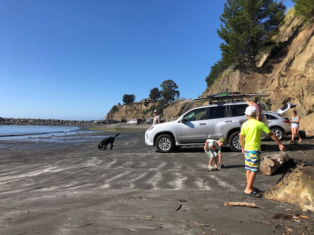
Shelter Cove Beach is a long dark sand beach on the south side of the town of Shelter Cove. This is the beach at the Shelter Cove Boat Launching Facility. The beach is protected from the west by Point Delgada and a rock jetty near the boat ramp so this is a great spot for kids to safely swim and enjoy the water. At low tide surfers sometimes walk or drive their trucks farther down the beach to the surf-exposed shoreline at Dead Man’s Beach. The Shelter Cove RV Park & Campground is above the cove and they have a small store and a deli. Black Sands Beach is a wider pedestrian-only beach on the north side of town.
30 persone del luogo consigliano
Shelter Cove
Shelter Cove Beach is a long dark sand beach on the south side of the town of Shelter Cove. This is the beach at the Shelter Cove Boat Launching Facility. The beach is protected from the west by Point Delgada and a rock jetty near the boat ramp so this is a great spot for kids to safely swim and enjoy the water. At low tide surfers sometimes walk or drive their trucks farther down the beach to the surf-exposed shoreline at Dead Man’s Beach. The Shelter Cove RV Park & Campground is above the cove and they have a small store and a deli. Black Sands Beach is a wider pedestrian-only beach on the north side of town.
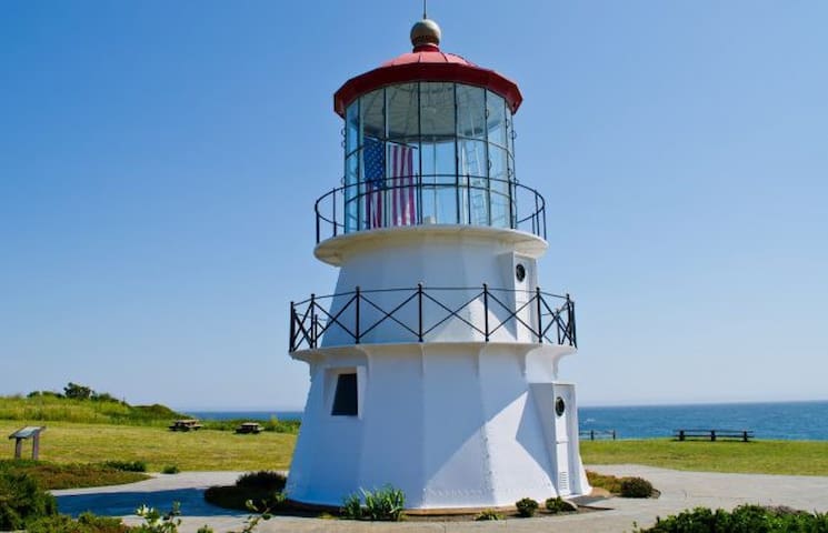
Mal Coombs Park
Mal Coombs Park is located on the west side of the small resort town of Shelter Cove. There is a small rocky beach hidden away below the park. Many visitors never get past the Shelter Cove Lighthouse which stands in the center of the park. The lighthouse is actually the old Cape Mendocino Lighthouse which was moved to this location near Point Delgada and reassembled in the year 2000. The park has a parking lot and picnic tables just steps from the lighthouse and the beach. At low tide, the abundant marine life is exposed in tide pools below the beach.
We love the spot. The lighhouse is really cool and there are some great picknick tables and one that is really long that can accommodate a large group. The stairs to the beach and tidepools are also at this place. You can hike along the shoreline and at low tide, you can explore the tide pools.
30 persone del luogo consigliano
Shelter Cove
We love the spot. The lighhouse is really cool and there are some great picknick tables and one that is really long that can accommodate a large group. The stairs to the beach and tidepools are also at this place. You can hike along the shoreline and at low tide, you can explore the tide pools.
Usal Beach
Usal Beach at Usal Campground is the southernmost beach in Sinkyone Wilderness State Park along the Mendocino North Coast. It’s a remote dark sand beach that’s over a mile long and quite deep at the mouth of Usal Creek. You can drive to Usal Beach via long windy roads, but it’s best with a 4WD or high-clearance vehicle and only when the roads aren’t wet. RV’s and cars with trailers are not advised on these roads. This is a seasonal area that is only open March through October typically. Usal Beach is popular with Jeep and 4×4 clubs because of this rugged drive and the ability to drive right onto the beach. The Lost Coast Trail begins at Usal Beach and takes hikers and backpackers north to Anderson Beach, Wheeler Beach, and beyond. The camp spots at Usal are in a meadow area not far from the beach
Usal Campground
This is a nice day trip from Shelter Cove during the summer months.
Sightseeing
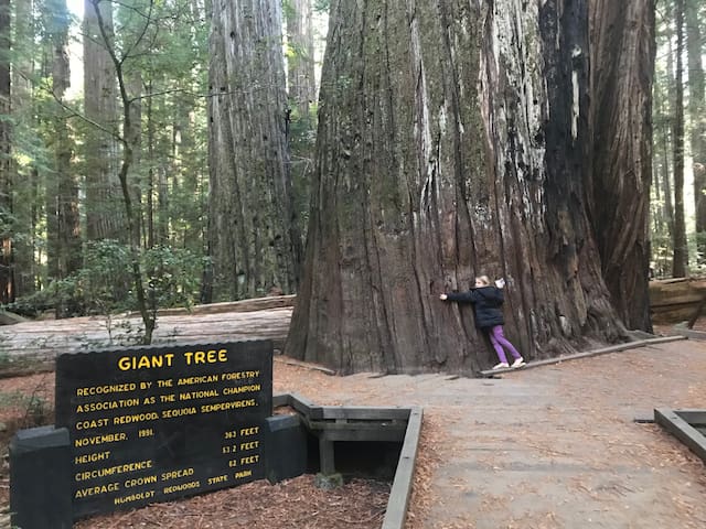
Shelter Cove is a great base camp for some of the most incredible hiking in California. A great day trip from the Cove is drive about 30 miles to Humboldt Redwoods State Park. The famous Avenue of the Giants is a 31 mile portion of Highway 101 the cuts through some of the most impressive Redwoods on the planet. You can definitely enjoy the beauty right from your car window, but there are several hikes in the area that will make the experience one to remember.
The Eel River also runs down the heart of The Avenue of Giants making for some amazing scenes and places to jump in the river to cool off.
Directions from the Cove
Continue on Shelter Cove Rd.
9.1 mi- Continue onto Briceland Rd - 12.2 mi
Turn left onto Redwood Dr- 1.8 mi
Redwood Dr turns right and becomes Dean Creek Rd - 262 ft
Turn left to merge onto US-101 N- 3.3 mi
Take exit 645 for Avenue of the Giants/State Route 254 toward Hooker Creek Road/Phillipsville- 0.2 mi
Merge onto CA-254 N/Avenue of the Giants
The Avenue of the Giants Continues North for about 30 miles
* A great loop trip from Shelter Cove
1. Stop at Founders Grove for 1/2 hike. This is about 20 miles north of where you get on the 101 from the cove
2. Then head west on Matole Rd and stop at
60 persone del luogo consigliano
Avenue Of The Giants
Avenue of the GiantsShelter Cove is a great base camp for some of the most incredible hiking in California. A great day trip from the Cove is drive about 30 miles to Humboldt Redwoods State Park. The famous Avenue of the Giants is a 31 mile portion of Highway 101 the cuts through some of the most impressive Redwoods on the planet. You can definitely enjoy the beauty right from your car window, but there are several hikes in the area that will make the experience one to remember.
The Eel River also runs down the heart of The Avenue of Giants making for some amazing scenes and places to jump in the river to cool off.
Directions from the Cove
Continue on Shelter Cove Rd.
9.1 mi- Continue onto Briceland Rd - 12.2 mi
Turn left onto Redwood Dr- 1.8 mi
Redwood Dr turns right and becomes Dean Creek Rd - 262 ft
Turn left to merge onto US-101 N- 3.3 mi
Take exit 645 for Avenue of the Giants/State Route 254 toward Hooker Creek Road/Phillipsville- 0.2 mi
Merge onto CA-254 N/Avenue of the Giants
The Avenue of the Giants Continues North for about 30 miles
* A great loop trip from Shelter Cove
1. Stop at Founders Grove for 1/2 hike. This is about 20 miles north of where you get on the 101 from the cove
2. Then head west on Matole Rd and stop at